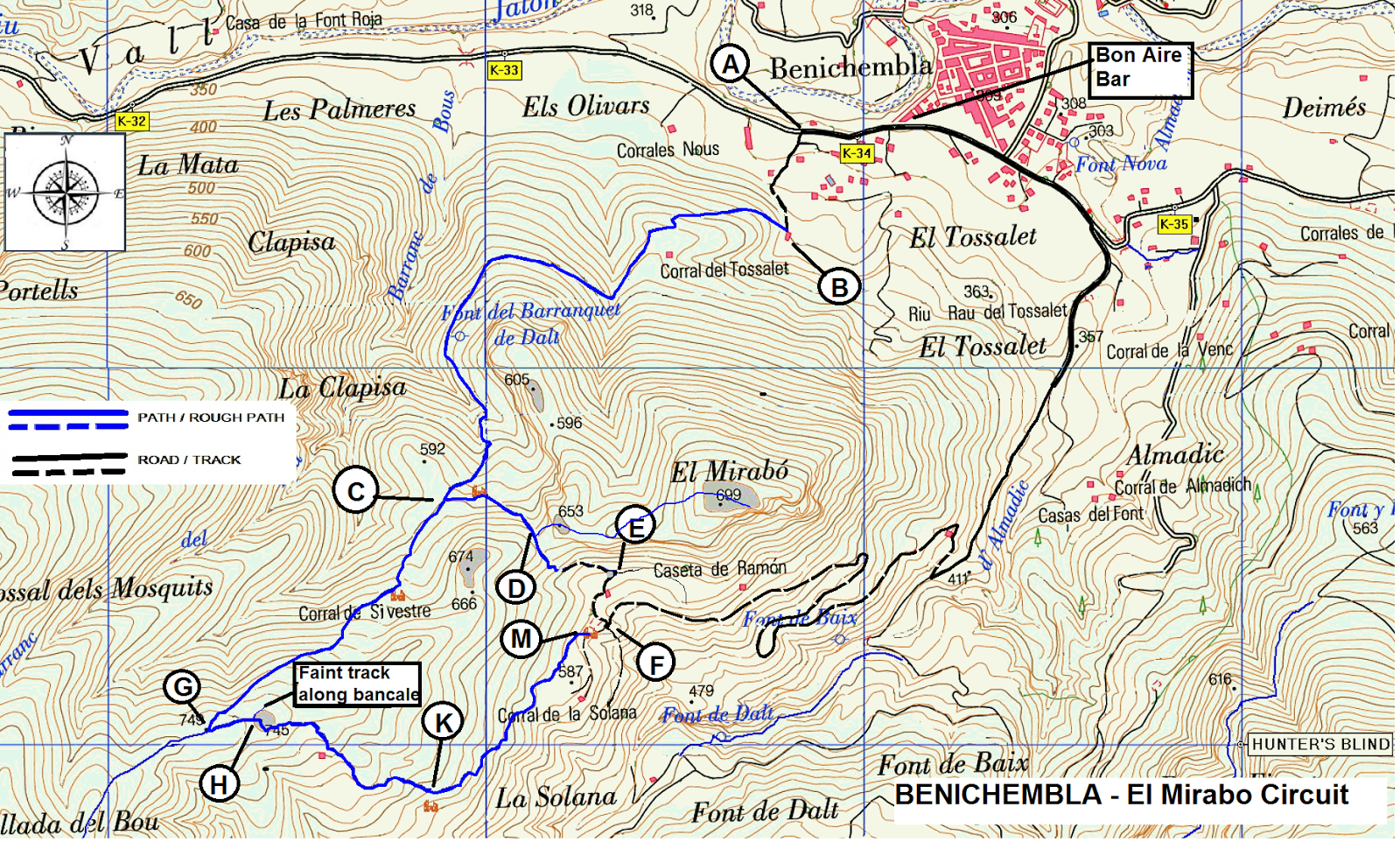
Showing posts with label Benichembla. Show all posts

Cordilleras Ridge Circuit from Benichembla

If you have already done the Cordillera Ledge walk (a must walk) this walk is a good follow-up.
Rather than walking along the lower ledge, this walk rises to the summit for a four kilometer of ridge walk before descending and returning to Benichembla via the Cocoll air strip.
Starting from Benichembla it begins with a very steep 45 min. ascent by road and very rough tracks. Most of the ascent is at the beginning of the walk.

Some of the times and distances have been estimated and will be confirmed a later date.


DISTANCE 15kmWALKING TIME  41/2 hrs- ASCENT 700mtrs. – GRADE S
Click here for GPS track
Click here for map and directions

Trasero de Caballo


Starting with a riverbed walk of 1 ½ km, over Col de Gaga and return via a mix of mozarabic trails and interesting riverbed. Due to overgrown sections, may be difficult to follow. Shorts are not recommended. Best done using GPS track as some ways are a little vague. 


 DISTANCE 11.5km. -  WALKING TIME 3 ¼ hrs. -  ASCENT 400 mtrs. - GRADE M

Click here for map and directions  or  Click here for just map
Click here for GPS track
Google map to start

FONTILLES CIRCUIT FROM MURLA

A moderate walk mainly on good tracks and paths with one unavoidable steep scramble. Not all the paths are well marked so some path finding skills are necessary. The route takes us around the interesting Fontilles leper colony, founded in 1902. This is a peaceful, spiritual place that warrants a separate visit. There is an information centre on the grounds.
The steep unavoidable scramble (with good foot and hand holds) takes us up the little tossal north of the Fontilles centre. The climb rewards us with spectacular views of the colony buildings and the impressive wall that encloses them. 


WALK SPECS: DISTANCE 10.2 km. -  WALKING TIME 3  hrs.  ASCENT 420mtrs. GRADE M Scr.

Click here for mapand directions  or  Click here for just map
Click here for GPS track
Google map to Murla

EL MIRABO CIRCUIT


Good walk on well established paths with optional trip to summit of Mirabo.
Just long enough to do before lunch at restaurant Bon Aire in Benichembla.

DISTANCE  7- 8.7Km. WALKING TIME  2 – 2 ½   hrs  ASCENT  420mtrs. GRADE  E/M

Click here for GPS track  or  Click here for just map
Click here for map and directions
Google map to start

FIG TREE WALK


Good leg stretcher on mainly forestry tracks with splendid views of Alfaro to the north and Cordilleras to the south. Interesting ruins.

DISTANCE 11.8km WALKING TIME 3h 10min. ASCENT 580mtrs.  GRADE Moderate

Click here for map and directions  or  Click here for just map
Click here for GPS track
Google map to start

Cordilleras Ledge Circuit (Almadic)

This walk follows above and looks down on the remote and peaceful Val de Almadic.
Starting at the town of Benichembla we begin with a very steep 45min accent by road. After this rather tough start we are rewarded by a wonderful path that takes us along a ledge on the south side of the valley at about 750 meters. This path crosses several small barrancos before reaching the end of the valley just below Cocoll Airstrip. Here we cross over to the North side of the valley and eventually begin our decent to Benichembla by the north side of El Mirabo
 
DISTANCE 13km – WALKING TIME 4 ¾hrs - ASCENT 720mtrs. – GRADE  S

Click here for directions
click here for photos
Click here for video
Click here for GPS track
Click here for alternative track
Google map to start

Benichembla: East Cocoll-Val de Almadic

The Val de Almadic, South of Benichembla, is relatively undiscovered and still has a feel of remoteness and peace. It is bounded on the S.E. by a massive, craggy, escarpment rising nearly sheer some 600 meters and cut by several dramatic “cleft” barrancos, which, after an exceptional downpour, would create waterfalls. To the NW the mountain rises less steeply and levels out to the “hill like” summit of Cocoll, (1048m), which only reveals its mountainous nature by its stupendous cliffs descending 600 meters into the Barranco de Dalt, to the West.

This walk takes you up the gentler N side of the valley to the Collado de Mirabo and then on a path with constant views of the escarpment to the South and on to the Airstrip just below Cocoll summit. This is followed by a rough path down the head of the Barranco Almadic and a welcome relaxed walk along a good track ending with a short mule path, pretty fuente and a good straight path back to your start.

The walk verges on hard, certainly if the ascent of Cocoll is included.

50% paths sometimes rough, 40% tracks. 10% roads. Muddy after heavy rain.

DISTANCE 11.2km WALKING TIME 3 ¼ hrs. ASCENT 575mtrs.GRADE Medium

Click here for map and directions
Click here for GPS track